"I am not one who was born in the custody of wisdom. I am one who is fond of olden times and intense in quest of the sacred knowing of the ancients." Gustave Courbet
Showing posts with label maps.cartography.art.. Show all posts

14 July 2026

Marvellous.


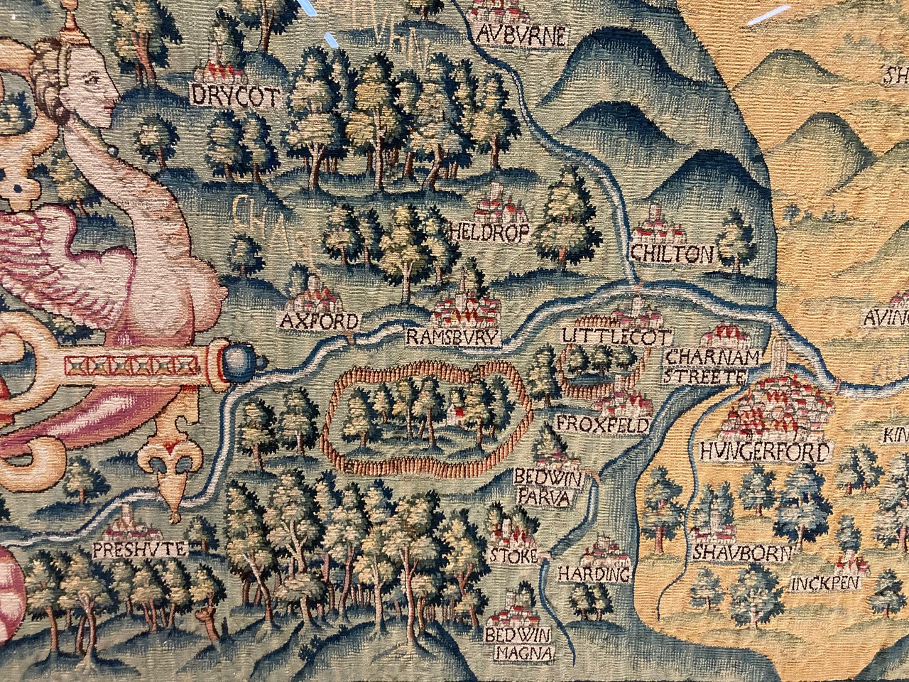
The Bodleian Map Room has the Oxfordshire Sheldon tapestry ...
Made from a mix of wool and silk the tapestries are both marvellous in their own right but are also important cartographic records, made at a time when England was beginning to be mapped properly for the first time. Each one would have originally measured approximately 15 by 20 feet and each has a "featured" county at its centre, bordered in red. Rivers and settlements feature prominently as do scenes of local interest such as the Rollright Stones, a prehistoric stone circle in north Oxfordshire, or a brief bit of text on the Worcestershire tapestry telling of a land slip. Important houses are shown though none as big as Sheldon’s, Weston House, which appears on all four tapestries, the very centre of the area the tapestries show. And what an area, when put together as a set of maps the range goes from as far north as the suburbs of Birmingham down past a beautiful, though comically inaccurate, White Horse at Uffington and from the Welsh border across to the Tower of London the whole of central England is depicted in glorious detail.

08 March 2026

Outliers.


The Bodleian Map Room reminds us that when mapping imaginary lands, normal rules don't apply ...
This description, from the Oxford English Dictionary, is what we all imagine when we think of a map, and when we look at that map we expect to see a location, whether a detailed town plan or country, continent or world, somewhere that exists both in reality and on paper.

Despite all this there are some outliers in the map world, maps of places that only exist in the mind, maps of imaginary lands. 

26 December 2025

Internal.
Homann, Danish Part of Norway, the Great Diocese of Akershus, 1729


Bodleian Map Room explores a unique Nordic mine map ...
This map shows the county of Akershus in Norway, centred around Christiania (now Oslo), in the eighteenth century. The map was drawn by Johann Baptist Homann, a largely self taught cartographer and engraver, in 1729. The area is described by a Latinized version of its name, Aggerhusiensis. About a quarter of the map is taken up by an illustration of a mine, with the surface cut away to show the internal workings.
Geographicus Rare Antique Maps has more, HERE.

17 June 2025

Happy Birthday, E.G. Squier

Squier and Davis, Newark Earthworks, Licking County, Ohio, 1848


Every man is a valuable member of society, who, by his observations, researches, and experiments, procures knowledge for men.

E.G. Squier, born on this day in 1821.

Every library should contain his book, Ancient Monuments of the Mississippi Valley.

22 February 2025

Fencing.


The Bodleian has fencing maps ...
In Robert Frost’s poem "Mending Wall" two neighbours walk the shared boundaries of their properties, checking on the condition of the wall separating their land and making repairs where necessary. At one point the narrator teases his neighbour on the need for the wall, “My apple trees will never come across and eat the cones under his pines, I tell him”. The neighbour replies, simply and memorably, “Good fences make good neighbours”.

Frost loves the phrase so much that it’s repeated again, to close the poem, and I’m reminded of this when looking at these two estate maps, of Down Manor from 1718 and Mowden Hall, 1762, both in Essex. Both are typical examples of an estate plan, are in manuscript form and show the holdings and field names of each estate (with sizes in acres, roods and perches). The connection with Frost comes with both showing boundaries in two different colours, according to ownership and according to responsibility of maintenance, to mark the outer boundaries of each estate. Any boundary dispute in the future would be easily settled with reference to the map. The importance of boundary fences are obvious, the need to keep animals out of certain fields and in others, as a way of separating good land from not so good and as a way of marking the limit of your land from your neighbour. The Down Manor map nicely calls the fencing surrounding the property "Out fencing."

11 January 2025

Michigan.


On this day in 1805, President Thomas Jefferson signed an act of the United States Congress that made the most beautiful part of the planet the Michigan Territory.

17 June 2024

Behind.


There’s no blank spots on the map anymore, anywhere on earth. If you want a blank spot on the map, you gotta leave the map behind.

Jon Krakauer, from Into the Wild

28 April 2024

Revealed.

Hall, The Deluge, 1830


The Bodleian Map Room explores Edward Quin's 1830 atlas ...
The beauty of Quin’s atlas comes from this sense of mystery achieved by revealing the known parts of the World according to the period of the map, with the rest of the World covered by thick, dark billowing clouds. With our knowledge of the World growing with each map the clouds withdraw a little further and more of the World is revealed.

09 February 2024

Mind's

Ortelius, Typus Orbis Terrarum, 1587


My mind’s a map. A mad sea-captain drew it   
Under a flowing moon until he knew it;
Winds with brass trumpets, puffy-cheeked as jugs,   
And states bright-patterned like Arabian rugs.   
“Here there be tygers.” 
“Here we buried Jim.”   
Here is the strait where eyeless fishes swim   
About their buried idol, drowned so cold   
He weeps away his eyes in salt and gold.   
A country like the dark side of the moon,   
A cider-apple country, harsh and boon,   
A country savage as a chestnut-rind,
A land of hungry sorcerers.
                                              
Stephen Vincent Benet, from "Difference"

08 February 2024

Valuable.

Tolkien, Middle Earth, 1955


To those devoid of imagination, a blank place on the map is a useless waste; to others, the most valuable part.

05 January 2024

Shadowed.

Tolkien, Wilderland, 1937


O! Wanderers in the shadowed land
despair not! For though dark they stand,
all woods there be must end at last,
and see the open sun go past:
the setting sun, the rising sun,
the day's end, or the day begun.
For east or west all woods must fail ...

J.R.R. Tolkien, from The Fellowship of the Ring

14 November 2023

Full.
Another gem from The Bodleian Map Room ...
William Grent made the first version of this beautifully elaborate and descriptive double hemisphere World map in 1625. Little is known about Grent and there are no other listings for any work apart from his World map, which went on to be copied and improved on a number of times. John Speed used it as the basis for his World map published in his "A Prospect of the most Famous Parts of the World" atlas a year later while Thomas Jenner, publisher, bookseller and engraver, produced copies in 1632 and, the date of this copy, 1641.

It is a map so full of information, iconography and allegory that it is hard to know where to start. It may not be the best topographically – it’s one of the first to show California as an island despite numerous examples both before and after showing the location as a peninsula – but is still full of useful information about places. "At the Cape of Good Hope all that passe to and from the East Indies ancour to take in fresh vittaile and meete newes one of another affaires" (a blog about "rounding the Horn" can be found here) and in another part of the map we’re told that "This south land undiscovered commonly known as Terra Australis…can not certainly be affirmed…only some few coasts thereof have appeared to sea men driven there upon by extremity of weather…"

08 September 2023

Lovely.

Today's rabbit hole finds us wandering through The Bodleian Library's Map Room ...
At twenty minutes to two on the afternoon of the 8th September 1785 Mr Thomas Baldwin, to the ‘tears of delight and apprehension, the misgivings of humanity, and other sensations of surprize’ of the inhabitants of Chester took flight in a hot air balloon. Ascending to a height of four miles over Chester Baldwin was able to look down on the earth, a true birds-eye view. He wrote of his adventures in a book published the following year, Airopaidia : or aerial recreation, describing the voyage as well as giving a detailed account of the preparation involved in the flight (for instance a canon was fired at 7 am to let people know that the balloon was being inflated), the equipment taken onboard (as well as ballast brandy and feathers to throw out at various times to check wind speed and direction), and, rather worryingly, what to do if you start to descend too quickly. Baldwin also included some lovely original maps showing the views from above the clouds ...

Chester, A Balloon Prospect from Above the Clouds, 1786

26 August 2023

Excellent.

An excellent book ...


Nat Williams, James and Bettison Treasures Curator at the National Library of Australia, discusses the Fra Mauro mappamundi ...

02 July 2023

Escalate.

O'Sullivan, Little Round Top, 1863


On the second day of battle, the Union defends a fishhook-shaped range of hills and ridges south of Gettysburg. The Confederates wrap around the Union position in a longer line. That afternoon Lee launches a heavy assault commanded by Lieut. Gen. James Longstreet on the Union left flank. Fierce fighting rages at Devil's Den, Little Round Top, the Wheatfield, the Peach Orchard, and Cemetery Ridge as Longstreet’s men close in on the Union position. Using their shorter interior lines, Union II Corps commander Maj. Gen. Winfield S. Hancock and others move reinforcements quickly to blunt Confederate advances. On the Federal right, Confederate demonstrations escalate into full-scale assaults on East Cemetery Hill and Culp’s Hill. Although the Confederates gain ground on both ends of their line, the Union defenders hold strong positions as darkness falls.

The Gettysburg episode of the Trust's masterful series, In Four Minutes ...

An animated map of the battlefield ...

04 June 2023

Isochronic.


Res Obscura demonstrates history through isochronic maps...
Sometimes, however, historians manage to do something truly interesting with maps.

My favorite example has long been a series of maps by the French historian Fernand Braudel, featured in his first book The Mediterranean and the Mediterranean World in the Age of Philip II. The history of the book itself is pretty fascinating in its own right: remarkably, Braudel managed to write much of it while he was in a Nazi prisoner of war camp in Lübeck, Germany, between 1942 and 1945.

Three of Braudel's maps from the book, which I've stitched together into a single GIF, brilliantly depict the time it took for a letter to reach Venice if it had been sent from a number of different cities: Moscow, Lisbon, Istanbul, and more.