Showing posts with label map. geography. design.. Show all posts
Showing posts with label map. geography. design.. Show all posts
07 June 2023


04 June 2023
Isochronic.
Galton, Isochronic Passage Chart, 1881

Res Obscura demonstrates history through isochronic maps...
Sometimes, however, historians manage to do something truly interesting with maps.My favorite example has long been a series of maps by the French historian Fernand Braudel, featured in his first book The Mediterranean and the Mediterranean World in the Age of Philip II. The history of the book itself is pretty fascinating in its own right: remarkably, Braudel managed to write much of it while he was in a Nazi prisoner of war camp in Lübeck, Germany, between 1942 and 1945.Three of Braudel's maps from the book, which I've stitched together into a single GIF, brilliantly depict the time it took for a letter to reach Venice if it had been sent from a number of different cities: Moscow, Lisbon, Istanbul, and more.

24 May 2023
Urgency.
An image which captures, perfectly, the urgency of life in the rare map trade: me, answering a customer enquiry after a good lunch. pic.twitter.com/zEKASDLstV
— Tim Bryars (@TimBryars) May 22, 2023
08 February 2023
Findings.
An excellent book ...

We do not know whether [Hipparchus] drew maps--perhaps he did--but the truth is that in his day he could not possibly have applied his projections to the globe because the necessary data, in the form of correct findings of latitudes and longitudes of a very large number of places over the known areas of the earth, were not available. This was the weakness of all Greek cartographic science. In Greek times mathematics was in advance of mechanical instrumentation: There was no instrument for easily and correctly determining the longitude of places. However, the Piri Re'is and the other maps we went on to study, seemed to suggest that such an instrument or instruments had once existed, and had been used by people who knew very closely the correct size of the earth. Moreover, it looks as if this people had visited most of the earth. They seem to have been quite well acquainted with the Americas, and to have mapped the coasts of Antarctica.
Charles H. Hapgood, from Maps of the Ancient Sea Kings: Evidence of Advanced Civilization in the Ice Age
02 February 2023
Expansive.
Bretez, Plan of Paris, 1734

This expansive engraved view of Paris covers the first eleven arrondissements of modern Paris. With a combined width of over ten feet, the joined plan makes for an arresting centerpiece. Turgot's is perhaps the best record of Paris in the 18th century, before its transformation by Georges-Eugène Haussmann and Emperor Napoleon III. It is widely regarded as one of the most important city views of all time.
The Mayor of Paris, Michel-Étienne Turgot, commissioned Louis Bretez, a member of the Académie de Saint-Luc to create an impressive image of the city. He was given license to survey wherever he needed and could enter private property if the task required. The end result was to be a statement piece, one which was presented to dignitaries, foreign and domestic alike, to reinforce their esteem of Paris.
Historians suspect that Bretez was awarded the commission in part because of the work he had already done on architectural perspective, some of which was published in his 1706 book La perspective pratique de l'architecture . Claude Lucas was Bretez's engraver.
A detailed view of this wonder is available at Barry Lawrence Ruderman.
31 January 2023
Longitude.
Longitude, the story of John Harrison's development of the marine chronometer, featuring Dumbledore and Charles Ryder ...
09 October 2022

11 January 2022
Michigan.
Carey, A New Map of Part of the United States of North America, exhibiting the Western Territory, Kentucky, Pennsylvania, Maryland, Virginia & C. also, the Lakes Superior, Michigan, Huron, Ontario & Erie; with Upper and Lower Canada & C. from the latest Authorities, 1805

Thomas Jefferson created the Michigan Territory on this date in 1805.
10 October 2020
Introduced.

But ... It has this life beyond the evidence itself, and it has this value to some people beyond the evidence itself.
Today ... fundamental questions about the Map remain unanswered.
PBS' presentation, "The Viking Deception," on NOVA ...
10 August 2020
Unique.

In school, we all learned about Paul Revere and his famous
April 18, 1775 ride through the Massachusetts countryside warning of an
impending British armed force marching from Boston, MA to the small towns of
Lexington and Concord. But, of course, there is much more to the story,
including the British commander of all troops in North America, British spies,
patriotic tavern keepers, an unsigned manuscript map, and a Boston publisher.
Tensions between the colonies and England reached a boiling
point in December 1773 with the Boston Tea Party when a group of
colonists dumped tea from England into Boston Harbor. As a result, the British
Parliament passed a series of laws that, among other things, installed British
General Thomas Gage, as the governor of the Colony of Massachusetts in May
1774. By the winter of 1774-1775, however, in the face of continued rebellious
activities, General Gage argued for an 18th century troop “surge” – as
many as 20,000 additional troops – to pacify the countryside.
Several years ago, I stumbled across an unsigned manuscript
map with the supplied title of “Roxbury to Concord. Roads & distances,
&c.” This unique map was acquired by the Library of Congress in 1867 as a
part of the Peter Force Collection, which includes more than 750
Revolutionary era printed and manuscript maps transferred to the Geography and
Map Division.
05 May 2020
Process.
Mitchell, British and French Dominions in North America, 1757

In Early America, people used maps to define physical and political borders and to illustrate ideas about the world. The processes of mapmaking—surveying, drawing, engraving, and printing—could produce competing visions of the same landscape.
In the 18th and 19th centuries, maps of North America were battlegrounds on which European empires, Native American nations, and North American colonists fought for control of territory and resources. After the American Revolution, maps became part of the nation-building process.
Even as mapmakers sought to represent a connected and united citizenry, maps reinforced the exclusion of many groups from full participation in the new nation. The United States imagined by these maps continued to displace Native peoples from their lands to create spaces for westward expansion. Maps from the Early Republic (c. 1780–1816) reveal just how complicated the process of nation-building was—and continues to be today.
CONNECT
Click HERE to explore this map in the APS Digital Library
In Early America, people used maps to define physical and political borders and to illustrate ideas about the world. The processes of mapmaking—surveying, drawing, engraving, and printing—could produce competing visions of the same landscape.
In the 18th and 19th centuries, maps of North America were battlegrounds on which European empires, Native American nations, and North American colonists fought for control of territory and resources. After the American Revolution, maps became part of the nation-building process.
Even as mapmakers sought to represent a connected and united citizenry, maps reinforced the exclusion of many groups from full participation in the new nation. The United States imagined by these maps continued to displace Native peoples from their lands to create spaces for westward expansion. Maps from the Early Republic (c. 1780–1816) reveal just how complicated the process of nation-building was—and continues to be today.
CONNECT
22 February 2020
Perfect.

He had bought a large map representing the sea,⠀
Without the least vestige of land:⠀
And the crew were much pleased when they found it to be⠀
A map they could all understand.⠀
“What’s the good of Mercator’s North Poles and Equators,⠀
Tropics, Zones, and Meridian Lines?“⠀
So the Bellman would cry: and the crew would reply⠀
“They are merely conventional signs!⠀
“Other maps are such shapes, with their islands and capes!⠀
But we’ve got our brave Captain to thank:⠀
(So the crew would protest) “that he’s bought us the best–⠀
A perfect and absolute blank!"⠀
Lewis Carroll, from The Hunting of The Snark
10 September 2019
Hurricanes.

160 years of hurricanes recorded on one picture. Pink: Cat. 1, Blue: Cat. 2, Turquoise: Cat. 3, Yellow: Cat. 4, Red: Cat. 5.
16 May 2019
Catalogues.
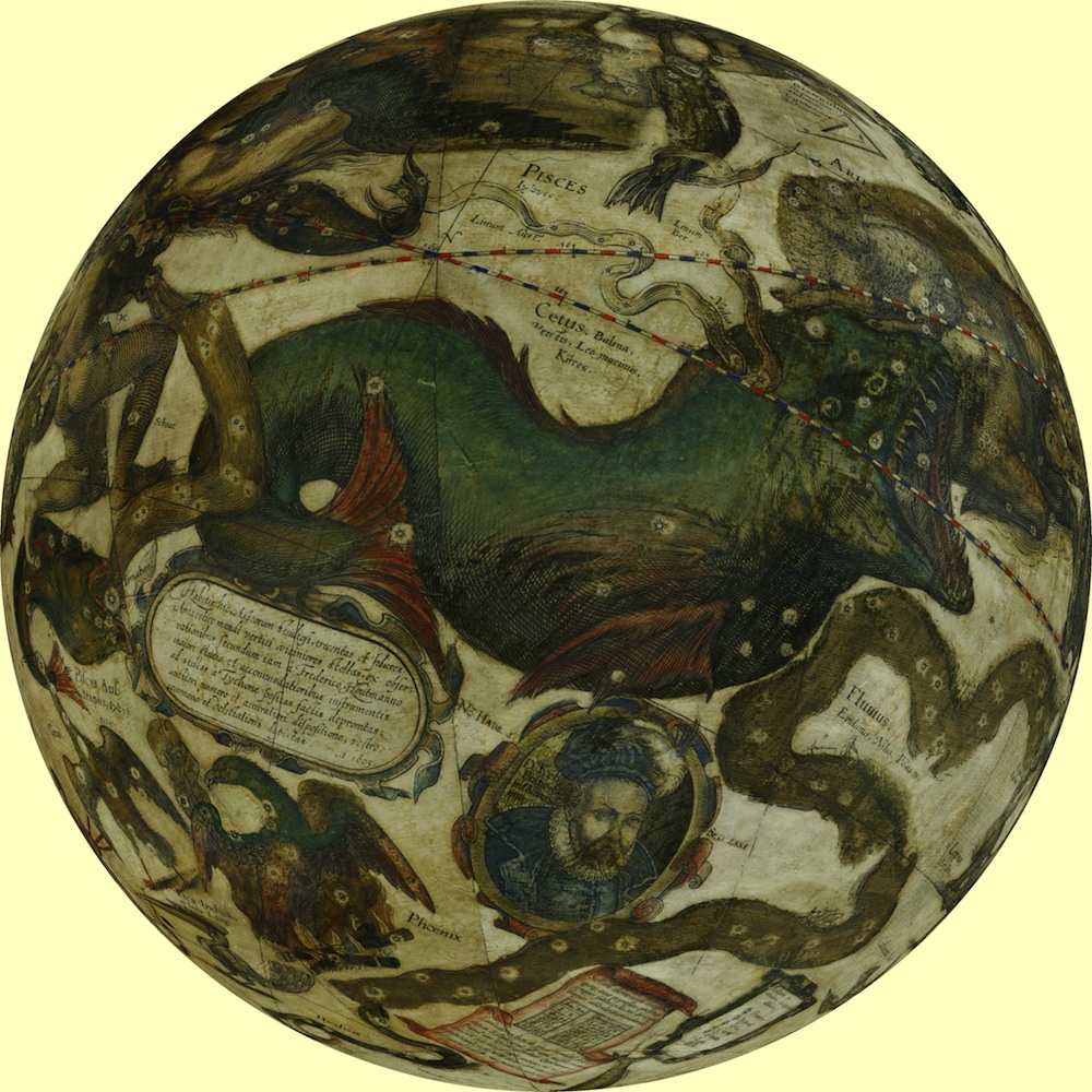
To train in stargazing, the publisher and mapmaker Blaeu traveled to the island of Hven in Denmark, where he studied with Tycho Brahe, the preeminent astronomer of the period, whose detailed observations made possible Johannes Kepler’s discovery of the three laws of planetary motion. This globe relies on Tycho’s star catalogues to show the positions of the Northern stars, and it also prominently portrays the Danish astronomer.
CONNECT
21 March 2019
Patterned.
d"Isle, Michigan Territory, 1718

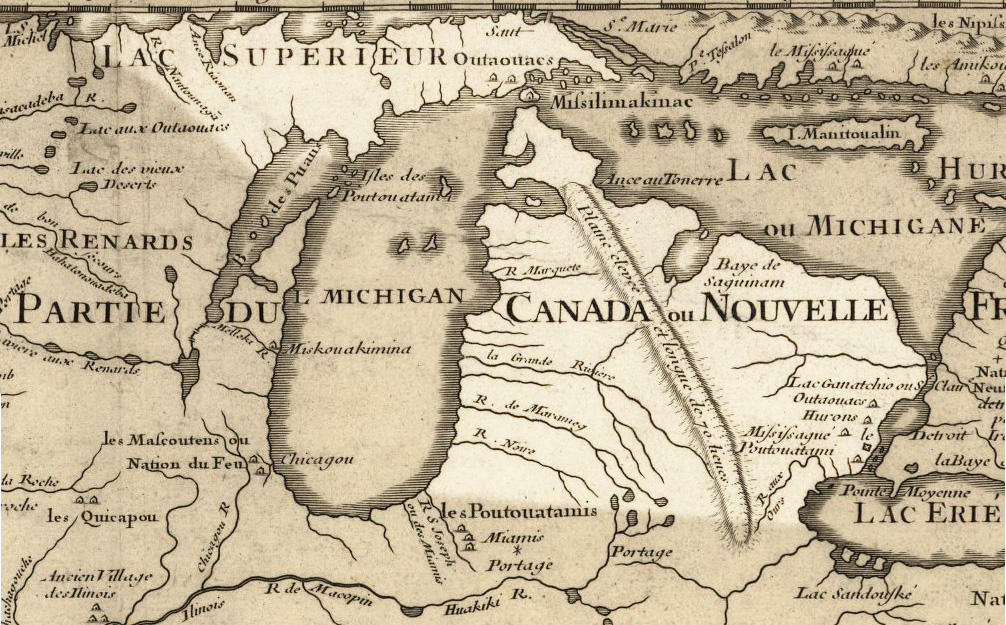
God knitted a mitten of wood, rock and lime,
Made a foundation to last through all time.
He planted his palm with Hemlock and Pine,
Then blessed it with rain and sunshine.
In all the world there’s no other land
That God himself patterned from his own hand!
Michigan.
Millie Miller
14 October 2018

02 September 2018
Ambitious.

“Cartography was not born full-fledged as a science or even an art,” wrote map historian Lloyd Brown in 1949. “It evolved slowly and painfully from obscure origins.” Many ancient maps made no attempt to reproduce actual geography but served as abstract visual representations of political or theological concepts. Written geography has an ancient pedigree, usually traced back to the Greeks and Phoenicians and the Roman historian Strabo. But the making of visual approximations of the world seemed of little interest until later in world history. As “mediators between an inner mental world and an outer physical world”—in the words of historian J.B. Harley—the maps of the ancients tended to favor the former. This is, at least, a very general outline of the early history of maps.
Harley’s definition occurs in the first chapter of Volume One of The History of Cartography, a massive six-volume, multi-author work tracing map making from prehistoric times up to the twentieth century; “the most ambitious overview of map making ever undertaken,” Edward Rothstein writes at The New York Times.
20 May 2018

14 May 2018
Grand.
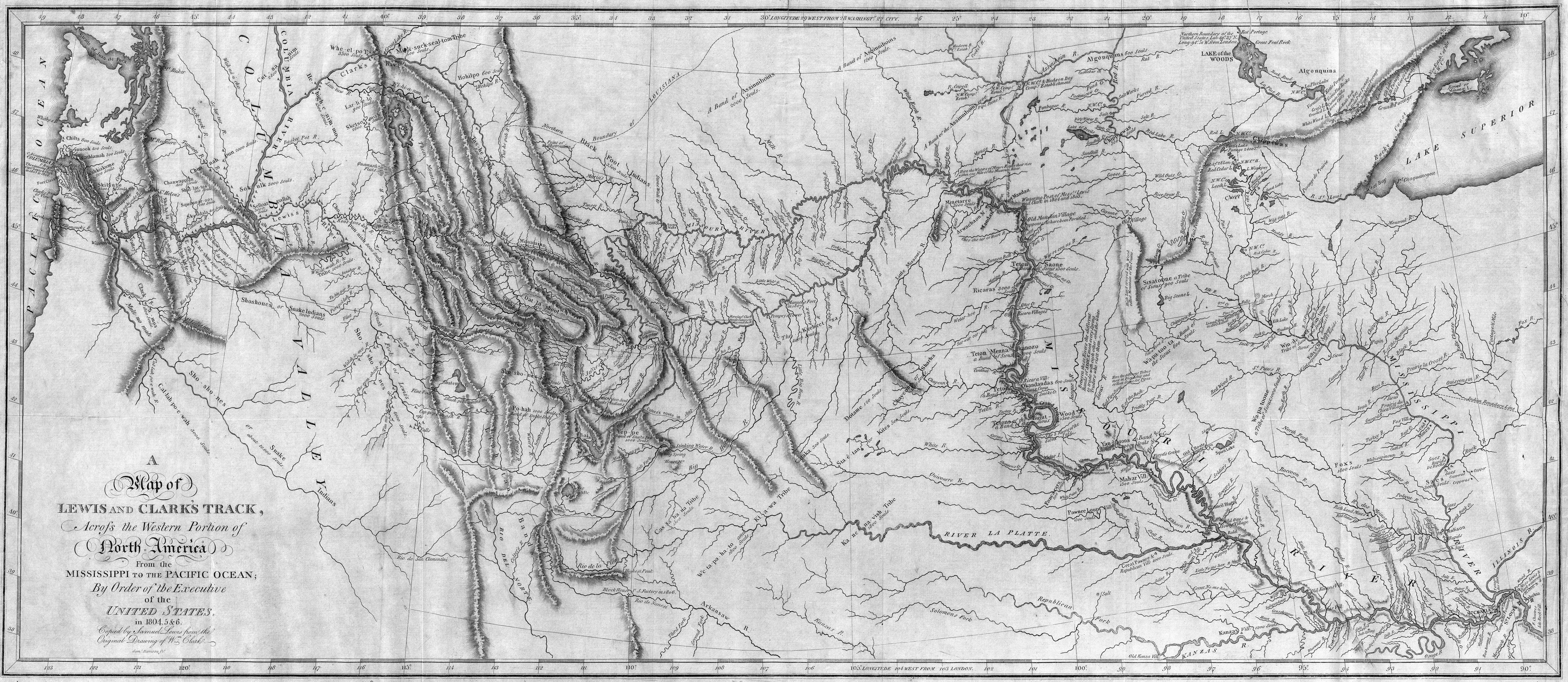
Clark/Lewis, S., A Map of Lewis and Clarks' Track Across the Western Portion of North America from the Mississippi to The Pacific Ocean; by Order of the Executive of the United States in 1804, 5 & 6, 1814
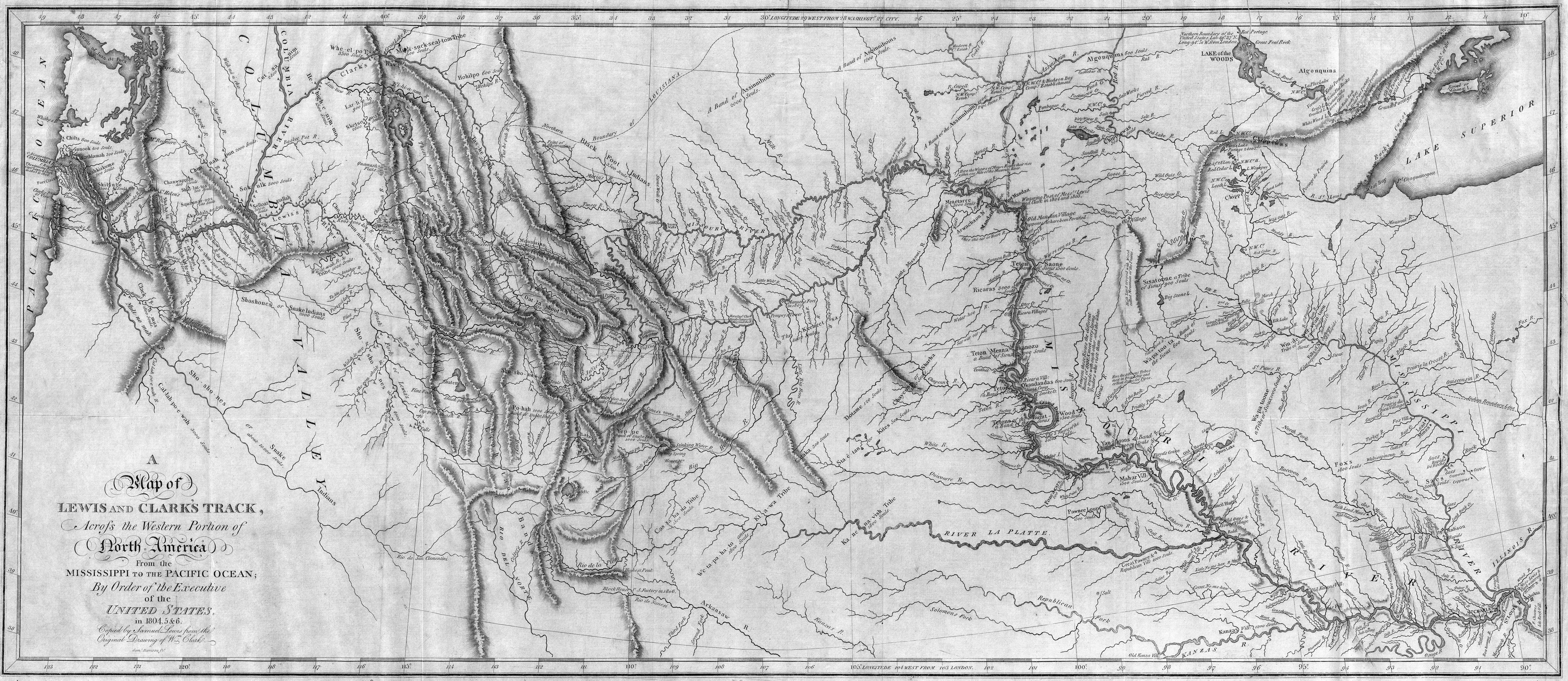
On this day in 1804, Lewis and Clark began their grand camping trip.
CONNECT
On this day in 1804, Lewis and Clark began their grand camping trip.
CONNECT
27 April 2018

Subscribe to:
Posts (Atom)